
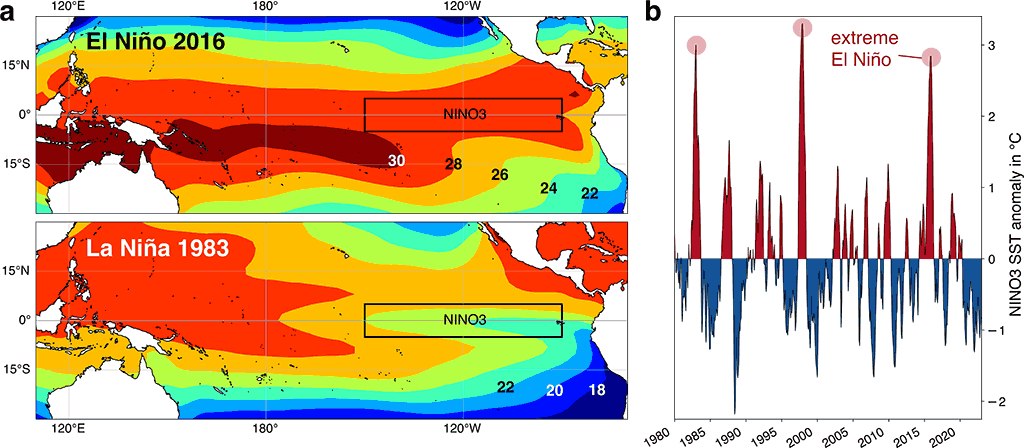
The El Niño Southern Oscillation (ENSO) is one of Earth’s most influential climate systems, affecting weather patterns across the globe. During 2026, meteorologists are closely monitoring an unusual combination of two major ocean events: a strengthening Super El Niño in the Pacific Ocean and a rare Atlantic Niña in the tropical Atlantic.
Although these ocean temperature anomalies appear opposite warm waters in the Pacific and cooler waters in the Atlantic they can reinforce one another in the atmosphere. Together, they may reduce Atlantic hurricane activity by increasing wind shear, stabilizing the atmosphere, and limiting tropical storm development.
This article explains how ENSO works, what Atlantic Niña means, why these patterns matter for the 2026 Atlantic hurricane season, and what they could reveal about winter weather later this year.
What Is the El Niño Southern Oscillation (ENSO)?
ENSO is a naturally occurring climate cycle involving changes in sea surface temperatures and atmospheric pressure across the tropical Pacific Ocean.
The three phases include:
- El Niño – Warmer-than-average Pacific waters.
- La Niña – Cooler-than-average Pacific waters.
- Neutral – Near-average ocean temperatures.
These phases influence rainfall, temperatures, droughts, floods, tropical cyclones, and jet stream patterns across many parts of the world.
Understanding Atlantic Niña
Atlantic Niña is similar to Pacific La Niña but occurs in the equatorial Atlantic Ocean.
During an Atlantic Niña:
- Sea surface temperatures become cooler than average.
- Stronger trade winds increase ocean upwelling.
- Cooler water spreads across the tropical Atlantic.
- Atmospheric pressure rises over hurricane development regions.
Strong Atlantic Niña events are uncommon, especially during summer, making the current conditions particularly noteworthy.
Why 2026 Is Different
Meteorologists are observing two significant climate signals at the same time:
- A rapidly strengthening Super El Niño in the Pacific.
- An active Atlantic Niña across the tropical Atlantic.
Instead of cancelling each other out, these two patterns produce similar atmospheric effects that discourage hurricane formation over the Atlantic basin.
How Ocean Temperatures Influence Weather
Ocean temperatures and the atmosphere constantly interact.
Warm ocean water generally:
- Fuels thunderstorms
- Increases humidity
- Lowers air pressure
- Supports hurricane formation
Cooler ocean water tends to:
- Increase atmospheric stability
- Reduce evaporation
- Raise surface pressure
- Limit tropical storm development
These interactions explain why climate patterns such as ENSO have worldwide impacts.
Trade Winds: The Driving Force
Trade winds are steady easterly winds blowing across the tropics.
Their strength largely determines whether El Niño, La Niña, or Atlantic Niña develops.
Strong trade winds:
- Bring colder water to the surface
- Strengthen Atlantic Niña
- Suppress Pacific El Niño
Weak trade winds:
- Allow warm water to accumulate
- Encourage El Niño development
- Change global atmospheric circulation
Why El Niño Reduces Atlantic Hurricanes
One of El Niño’s most important effects is increased vertical wind shear over the Atlantic. Wind shear occurs when wind speed or direction changes with height.
Strong wind shear:
- Tears apart developing tropical storms
- Prevents hurricanes from strengthening
- Makes long-lived hurricanes less common
This is one reason El Niño years often experience fewer Atlantic hurricanes than La Niña years.
Atlantic Niña Adds Another Layer of Protection
Atlantic Niña contributes additional hurricane suppression by creating:
- Higher atmospheric pressure
- Sinking air
- Reduced rainfall
- Less moisture
- Greater atmospheric stability
These conditions make it harder for tropical systems to organize into hurricanes.
The Main Development Region (MDR)
The Main Development Region (MDR) stretches across the tropical Atlantic between western Africa and the Caribbean.
Many of the Atlantic’s strongest hurricanes begin in this region.
When the MDR experiences:
- Cooler waters
- Dry air
- Strong wind shear
- Higher pressure
Hurricane development becomes significantly less favorable.
Forecast for the 2026 Hurricane Season
Current seasonal forecasts suggest:
- Below-average Atlantic hurricane activity
- Fewer major hurricanes
- Reduced landfall risk for much of the U.S. coastline
- More active tropical conditions in the eastern Pacific
The greatest suppression is expected during August and September, which are normally the busiest months of the Atlantic hurricane season.
Does Lower Risk Mean No Hurricanes?
No. Even in quieter seasons, dangerous hurricanes can still occur. Historical examples demonstrate that one powerful storm can cause catastrophic damage despite overall below-average activity.
Residents in hurricane-prone regions should always remain prepared regardless of seasonal forecasts.
Atmospheric Circulation and Velocity Potential
Meteorologists often examine velocity potential, a measure of large-scale atmospheric motion.
Areas with:
Rising Air
- More thunderstorms
- Lower pressure
- Increased rainfall
- Greater hurricane development
Sinking Air
- Stable atmosphere
- Less cloud formation
- Drier conditions
- Reduced tropical cyclone activity
Forecasts for late summer 2026 indicate widespread sinking air over much of the tropical Atlantic.
Rainfall Patterns
Another indicator of hurricane activity is tropical rainfall.
Reduced rainfall generally suggests:
- Less atmospheric instability
- Fewer thunderstorms
- Reduced tropical convection
- Lower hurricane potential
Seasonal models currently indicate below-average rainfall across much of the tropical Atlantic and Caribbean.
Wind Shear Remains a Key Factor
Forecast models also project enhanced upper-level winds over the Atlantic.
This stronger wind shear is expected to:
- Disrupt developing tropical systems
- Limit hurricane intensification
- Shorten storm lifespans
Combined with Atlantic Niña, this creates an unfavorable environment for widespread hurricane development.
Possible Winter 2026–2027 Connections
Scientists continue studying links between tropical climate patterns and winter weather.
Although hurricane seasons do not directly determine winter conditions, both respond to larger atmospheric processes.
Some research suggests quieter Atlantic hurricane seasons may coincide with:
- Different jet stream patterns
- Increased chances of cold air outbreaks
- Greater opportunities for winter storms
- Changes in stratospheric circulation
The Polar Vortex Connection
The Polar Vortex is a large circulation of cold air surrounding the Arctic.
When it weakens:
- Cold Arctic air can move farther south.
- Winter weather becomes more variable.
- Snowfall opportunities may increase across parts of North America.
Researchers continue investigating how ENSO and other climate patterns influence these winter processes.
What This Means for the United States
Current climate signals suggest:
- Lower-than-average hurricane activity is possible during 2026.
- Atlantic Niña and Super El Niño both support hurricane suppression.
- Tropical development may be slower across the Atlantic basin.
- The Pacific is likely to remain more active than normal.
However, hurricane forecasts describe seasonal averages—not individual storms. Coastal communities should continue monitoring official forecasts throughout the season.
Final Thoughts
The El Niño Southern Oscillation (ENSO) remains one of the world’s most important climate drivers. In 2026, the combination of a strengthening Super El Niño and a rare Atlantic Niña is creating atmospheric conditions that could suppress Atlantic hurricane activity by increasing wind shear, stabilizing the atmosphere, and reducing tropical storm development.
While seasonal outlooks currently point toward a quieter Atlantic hurricane season, no forecast can eliminate the possibility of a damaging landfall. At the same time, these evolving ocean patterns may provide valuable clues about broader weather trends heading into winter 2026–2027. Scientists will continue monitoring ocean temperatures, atmospheric circulation, and the Polar Vortex to better understand how these interconnected systems influence weather across North America and beyond.